Get Complete Project Material File(s) Now!
The malaria vector
There are about 400 different species of Anopheles mosquitoes, but only 30 of these are vector of major importance for human malaria transmission (WHO, 2014). Genus of the Anopheles gambiae and Anopheles funestus are dominant and responsible for malaria transmission in the sub-Saharan Africa. Anopheles gambiae is the most anthropophagic species in the complex and the most important, probably the world’s most efficient malaria vector with characteristic indoor and outdoor resting. Anopheles arabiensis species of the Anopheles gambiae complex is dominant vector in malaria endemic region of South Africa. Other species of vectors regarded as secondary malaria vectors found South Africa include Anopheles pharoensis and Anopheles maculipalpis (Bedford 1928).
Global malaria situation
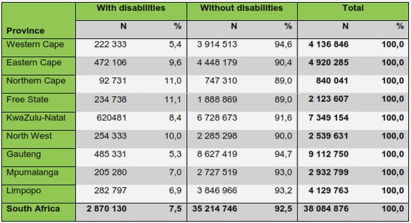
Children under age of 5 years and pregnant women are most prone to malaria infection (Greenwood et al., 2005). Other groups at risk include non-immune travellers, refugees, displaced persons and labourers entering endemic areas (WHO, 2000d). Under 5 years children are particularly at risk because of their relatively less developed immunity to malaria and the decrease in passively acquired immunity
Application of mathematical and statistical models in malaria studies
Malaria as a disease has been studied over a long period of time by various researchers cutting across several fields of studies, hence, there exist vast literatures describing various approaches ranging from the understanding of the biology of the vector, the parasites, the transmission, its control and prevention. The use of several approaches can facilitate the understanding of different stages of the disease by integrating available information and extrapolating it (Mandal et al., 2011). According to the malERA Consultative Group on Modeling, it is pinioned that a combination of several approaches, instead of a solitary type of modelling, may be a bold step towards malaria eradication and its general control.
Application of geographic information systems and remote sensing in malaria
research and control in South Africa: a review Abiodun Morakinyo Adeolaa* , Joel OBotaia Jane Mukarugwiza Olwochb Hannes CJ de W Rautenbacha, Ahmed M Kalumbaa Philemon L Tselaa, Mayowa Omolola Adisaa, Nsubuga Francis Wasswaa, Paul Mmtonia and Ausi Ssentongoa a Department of Geography, Geoinformatics and Meteorology, University of Pretoria, Hatfield, South Africab South African Space Agency (SANSA), Earth Observation Directorate, Silverton, South Africa
Remote sensing and malaria study in South Africa
RS is defined as the acquisition of information about an object or phenomenon without direct or physical contact with it (Jensen, 2007). For instance; electromagnetic radiation reflected or emitted by the Earth’s surface can be recorded by sensors on board satellites. Since the launch of Landsat-1 41 years ago and other satellite sensors like, Terra (ASTER and MODIS) in 1999, NOAA-M (AVHRR) in 2002, Radarsat-1 (SAR) in 1995 and Meteosat-7 (VISSR) in 1997, the use of remotely sensed data to map and monitor earth surface features has been on the increase (Ceccato et al., 2005).
Chapter 1: Introduction
The malaria parasite and vector
The malaria parasite
The malaria vector
Global malaria situation
Malaria in Africa
Malaria in South Africa
Overall situation
Past and present malaria control actions in South Africa
Major stakeholders in malaria control
Cross-border initiatives
Surveillance
Elimination
Malaria in Mpumalanga, Nkomazi
Malaria, environment and climate Rationale for developing a forecasting system using spatial technologies
Research question
Research aim and objectives
Aim
Objectives
Key concepts and conceptual framework
Chapter 2: Literature review
Application of mathematical and statistical models in malaria studies
Application of GIS and remote sensing in malaria studies
Chapter 3: Spatial distribution of mosquito habitats and malaria risk
Landsat satellite derived environmental metric for mapping mosquitoes breeding habitatin
Chapter 4: Environmental factors and human populations
Environmental factors and population at risk of malaria in Nkomazi municipality, South Africa
Chapter 5: Spatial modelling and forecasting
Forecasting malaria incidence using remotely sensed climatic factors in Nkomazi local
municipality, South Africa 95
Chapter 6: Summary and conclusions
Curriculum vitae