Get Complete Project Material File(s) Now! »
Chapter 3. Land-based stressors are key drivers of mangrove cover change in the Auckland Region, New Zealand
Abstract
Both increases and decreases in mangrove forest area have been observed globally due to the influence of environmental changes and human impacts. This study quantifies the influence of land-use conversion in catchments, and climate and oceanic factors on the change in temperate mangrove forest cover over a period of 74 years (1940 to 2014). An improved mapping approach using aerial photographs and satellite images was applied to quantify changes in tall and dwarf mangrove cover and to identify the mechanism (expansion, gap filling, and loss) across 38 estuaries in the Auckland Region of New Zealand. Mangrove area increased from 2,313 ha in 1940 to 10,483 ha in 2014 (on average 3.2% yr-1), with higher rates in small estuaries (< 1,000 ha) than in large estuaries (> 1,000 ha). The area of the intertidal mudflat habitat, i.e. potential area for mangrove colonisation, has doubled from 14,193 ha in 1974 to 28,764 ha in 2014. The increase in total mangrove area was explained primarily by gap filling followed by expansion. The proportion of expansion-related increase was predominantly seaward (82%) but mangroves also expanded upstream (16%). Boosted regression tree analysis revealed that catchment forest cover, sea level and mean annual air temperature explained around 85% of the variation in mangrove area. Periods of catchment forest clearing coincided with gains in mangrove forest area. Dwarf mangroves were more sensitive to changes in sea level, in particular over the past 25 years, when annual sea level rise exceeded sediment accumulation rates. Catchment land use, especially the clearing of forests, associated with increased sediment supply into estuaries is the strongest driver of mangrove forest gain, implying that land-use management is a necessary aspect of mangrove management.
Introduction
Mangrove forests are unique ecosystems located in the inter-tidal zone between sea and land (Spalding et al., 2011). In total, mangrove forests cover 13.4 million ha of the Earth’s surface (Thomas et al., 2017). Mangrove ecosystems provide various ecological functions and services such as organic matter storage, carbon sequestration, water purification and coastal protection (Barbier et al., 2011). Globally, mangrove forest cover has decreased over the last few decades. The decrease is particularly evident in Southeast Asia, driven mainly by coastal development and conversion of mangroves into shrimp farms (Mayaux et al., 2005; Thomas et al., 2017).
However, in some other regions mangrove area has increased (Saintilan et al., 2014; Thomas et al., 2017), even though the findings are often restricted to single estuaries and based on short observation periods (Stokes et al., 2010). Recent studies highlight that long-term monitoring of mangrove cover is critical in order to understand the dynamic changes in mangrove area and to determine the influence of multiple, often confounding, factors such as land-use/cover, oceanic or climate factors on mangrove cover over time (Giri & Long, 2016). Large-scale and long-term studies are of particular importance at the southern and northernmost boundaries of mangrove distribution (i.e., temperate mangroves) to assess the effect of changes in climatic conditions on mangrove distribution (Giri & Long, 2016; Saintilan et al., 2014).
Around 1.4% of the global mangrove forest area is located in temperate regions such as South Africa, USA, Australia, New Zealand, and Japan (Morrisey et al., 2010). The upper North Island of New Zealand is one of the southernmost mangrove habitats in the world (Saintilan et al., 2014). As such, it is the ideal place to study how climatic and oceanic factors have affected mangrove cover over the last few decades. Given that temperate mangroves are at the edge of their distribution range they are likely to be more vulnerable and sensitive to climatic conditions than elsewhere (Lovelock et al., 2015a). Depending on the geographic region, the climatic factors that exert an influence on mangrove cover include temperature, frost events, and rainfall (Eslami-Andargoliet al., 2009; Godoy & Lacerda, 2015; Osland et al., 2017; Stuart et al., 2007). For example, relatively mild winters may have contributed to mangrove expansion in the Gulf of Mexico (Giri & Long, 2016).
Other potential drivers of temperate mangrove change are catchment-related factors, such as catchment forest cover and erosion rates (Giri & Long, 2016; Swales et al., 2007; Thomas et al., 2017). In New Zealand, steep topography and heavy rainfall result in a quick displacement of sediments and nutrients from the hilltops to the sea (Swales et al., 2007). Erosion rates may also be enhanced by deforestation in the catchment (Ewers et al., 2006; Glade, 2003). The deposition (infilling) of eroded, often silt and clay rich, sediment on previously sand-dominated tidal flats creates physical conditions facilitating mangrove establishment (Lundquist et al., 2011; Morrisey et al., 2010; Stokes et al., 2010; Stokes & Healy, 2005). Previous studies suggest that the degree of infilling and thus mangrove spread may depend on estuary size (Swales et al., 2007) but to date a detailed investigation of mangrove cover across estuary sizes is lacking.
Mangrove establishment has also been associated with oceanic factors (e.g., sea level, tidal amplitude, salinity, and wave action) (Duke et al., 1998; López-Medellín et al., 2011; Lovelock et al., 2015a; Sasmito et al., 2016). In the Firth of Thames, New Zealand, seaward expansion of mangrove forests is suggested to be limited to periods of low wind and wave conditions which allow seedling establishment (Lovelock et al., 2010; Swales et al., 2016). Significant increases of mangrove area along the Pacific coast of Mexico have been associated with sea level rise and warm surface waters during El Nino (López-Medellín et al., 2011). Oceanic factors differ both between and within estuaries, in particular between the estuary mouth (downstream) and upstream estuary regions (Duke et al., 2007; Hayes et al., 2017;
Spieret al., 2016). Oceanic factors have potential implications on mangrove distribution (Duke et al., 1998; Eslami-Andargoli et al., 2013). However, a systematic and quantitative assessment of mangrove cover change between and within estuaries and its drivers is lacking.
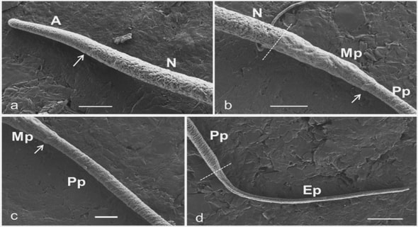
Studies on mangrove cover change are often simplistic in that mangrove cover is not differentiated by species or tree morphology/stature (e.g. Roslani et al., 2014). Temperate mangrove species, in particular Avicenna marina, often show distinct distributions with respect to stature, with taller mangrove trees (> 1 m in height, lower tree density) growing at the seaward fringe and adjacent tidal channels, and dwarf mangroves (< 1 m in height, higher tree density) growing in the interior and towards the shoreward fringe (Naidoo, 2010; Yang et al., 2013). Tree morphology and pneumatophores influence wave dissipation and turbulence, and thus modify sediment accretion and transport within mangrove forests (Horstman et al., 2018). These feedbacks in turn may affect the rate of further mangrove establishment and distribution, highlighting the importance of investigating tall and dwarf mangroves separately.
Previous studies have shown that mangrove cover change can take place in multiple directions or mechanisms, including seaward (Hoppe-Speer et al., 2015; Swales et al., 2007; Thomas et al., 2017), landward (Cavanaugh et al., 2014; Eslami-Andargoli et al., 2009; Saintilan et al., 2014), and upstream (Lee & Yeh, 2009; Moffett et al., 2015). In addition, mangrove cover change can also occur in the form of gap filling between mangrove patches (Horstman et al., 2018). However, different mechanisms for expansion have been poorly quantified in previous studies (Lundquist et al., 2014; Stokes et al., 2010; Stokes & Healy, 2005; Swales et al., 2007).
This is the first systematic and quantitative assessment of the mechanism and drivers of mangrove cover change. The objectives of this study are: 1) to quantify the changes in mangrove forest area by stature (morphology) and by mechanism (gap filling, expansion, transition, and loss) in their southernmost habitat; 2) to investigate the change in mangrove area within and between estuaries differing in size and across a tidal gradient, and 3) to determine the catchment, climatic, and oceanic factors driving mangrove cover change. To achieve these objectives, GIS-Remote Sensing (GIS/RS) techniques and field surveys were conducted in the Auckland Region located in the upper North Island of New Zealand.
Chapter 1. Introduction
1.1. Mangrove ecosystems
1.2. Temperate mangroves and Avicennia marina
1.3. Change in mangrove forest cover and landscape patterns
1.4. Drivers of change in mangrove area and landscape pattern
1.5. Carbon stocks in mangrove forests
1.6. Mangrove mapping and remote sensing
1.7. Study area and thesis aims
1.8. Thesis structure
Chapter 2. Sources of uncertainty in mapping temperate mangroves and their minimisation using innovative methods
2.1. Introduction
2.2. Methods
2.3. Results
2.4. Discussion
2.5. Conclusions
Chapter 3. Land-based stressors are key drivers of mangrove cover change in the Auckland Region, New Zealand
3.1. Introduction
3.2. Methods
3.3. Results
3.4. Discussion
3.6. Supplementary material
Chapter 4. Characterising landscape patterns in changing temperate mangrove ecosystems using a spatial metrics analysis
4.1. Introduction
4.2. Methods
4.3. Results
4.4. Discussion
4.5. Conclusions
4.6. Supplementary material
Chapter 5. Aboveground carbon stocks in mangroves across the Auckland Region, New Zealand
5.1. Introduction
5.2. Methods
5.3. Results
5.4. Discussion
5.5. Conclusion
5.6. Supplementary material
Chapter 6. Synthesis
6.1. Uncertainty in aboveground carbon stock quantification and upscaling
6.2. Implications of change in mangrove area and landscape patterns on aboveground carbon stocks
6.3. Limitations and recommendations for future research
6.4. Concluding remarks
References
GET THE COMPLETE PROJECT
Spatial distribution of mangroves in the Auckland Region (1940-2014) and implications for aboveground carbon stocks Suyadi