Get Complete Project Material File(s) Now! »
INTRODUCTION
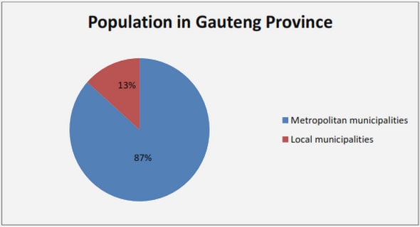
The Drakensberg range in South Africa is part of the Main Escarpment that extends as a passive margin around the African sub-continent. In KwaZulu-Natal the mountains are divided into three regions, the northern, central and southern Drakensberg (Fig. 1). Land-use within the Drakensberg area is mainly related to altitude, with the wilderness conservation areas situated in the escarpment zone (2200 m to above 3000 m a.s.l.) and farmland and small towns found below 2200 m a.s.l. in the foothills (Fig. 1). Typically, the escarpment edge lies between 2800-3000 m and defines the watershed border between the interior catchments of Lesotho that feed into the Orange River and the shorter and steeper catchments of the rivers in the province of KwaZulu-Natal (Fig. 1). The Drakensberg area has recently been declared a Trans-Frontier National Park and has become South Africa’s most valuable source of surface runoff since population growth and industrial development has placed increasing pressure on water resources (Mason and Jury, 1997). In the Johannesburg area, South Africa’s biggest city situated in the Gauteng province, water consumption has more than doubled since 1970. It is predicted that the domestic and industrial water demand in Gauteng is to increase from 980 million cubic metres to 3800 million cubic metres per annum and such a demand will exceed existing water resources (Waites, 2001). To address this resource problem and to supply water to Gauteng, two interbasin transfer schemes that operate in the Drakensberg region, the Tugela-Vaal transfer tunnel (TUVA) and the Lesotho Highlands Water Project (LHWP) were developed to transfer water from the upper catchments in KwaZulu-Natal and Lesotho to Gauteng (see Bell, 1999; Nel and Illigner, 2001; Waites, 2001). Although the Drakensberg is hydrologically important, climatic data are only predominantly collected in the foothills and very few contemporary analyses of these data have been forthcoming for this region.
Where KwaZulu-Natal borders on eastern Lesotho, the catchments generate nearly twice as much total runoff per unit of rainfall than for the average of South Africa as a whole, and this contributes a quarter of South Africa’s streamflow (Whitmore, 1970). Sources of precipitation over the Drakensberg include large-scale line and orographically induced thunderstorms, and cold fronts that develop as closed low-pressure cells in the western Atlantic and move across southern Africa in a west-northwest to east-southeast direction (Tyson et al., 1976).
Snowfalls occur on average eight times a year (Tyson et al., 1976), predominantly in the summit region, although the frequency could be underestimated since localised snowfalls are not considered (Boelhouwers and Meiklejohn, 2002).
Stations in the Drakensberg experience an average of 16 to 18 rain days in the months of December and January and the summer months November to March account for 70% of the annual rainfall, whilst May to August accounts for less than 10% (Tyson et al., 1976). Even though the high altitude region of the Drakensberg is an important catchment area, little research has focussed on assessing rainfall on the escarpment. Mean annual precipitation (MAP) measured in the 1930’s at Sani Pass (2865 m a.s.l.) on the southern Drakensberg escarpment edge was 995.8 mm (Killick, 1978). Three years of rainfall data are also presented from an unknown station at the summit of Organ Pipes Pass (2927 m a.s.l.) on the central Drakensberg escarpment. Mean annual precipitation measured at this site was 1609 mm (Killick, 1978) (Table 1). Carter (1967), in an assessment of the rainfall in Orange River catchment in Lesotho, published data from a station situated approximately 1,8 km west of the escarpment at an altitude of roughly 3121 m a.s.l. Based on five years of measurements in the early 1960’s, MAP for this site was 1068 mm. Sene et al. (1998) uses rainfall data from Sani Pass to assess the flow variations in the Lesotho Highlands and Schulze (1979) published data from Sani Pass and Cleft Peak, situated on the escarpment edge at 2880 m a.s.l., where rainfall was recorded for an unspecified short duration, and the monthly data synthesised to 21 years. Mean annual precipitation from both stations are unknown, but, estimates exceeding 1800 mm per annum are given using relief-based extrapolation from lower altitude (Tyson et al., 1976; Schulze, 1979), possibly exceeding 2000 mm per annum (Tyson et al., 1976) (Table 1).
INTRODUCTION
SECTION 1: LONG-TERM TRENDS IN RAINFALL AND RAINFALL VARIABILITY
Preface
Trends in rainfall total and variability (1970-2000) along the KwaZulu-Natal
Drakensberg foothills (Nel and Sumner)
Rainfall trends in the KwaZulu-Natal Drakensberg region of South Africa during
the Twentieth Century (Nel)
SECTION 2: MEASURED RAINFALL ATTRIBUTES, SURFACE TEMPERATURES AND GEOMORPHIC IMPLICATIONS
Preface
First rainfall data from the KZN Drakensberg escarpment edge (2002 and 2003) (Nel and Sumner)
Observations on daily rainfall events in the KwaZulu-Natal Drakensberg (Nel)
Intensity, energy and erosivity attributes of storm events in the Drakensberg, South Africa (Nel and Sumner)
Intra-storm attributes of extreme storm events in the Drakensberg, South Africa (Nel)
Surface-climate attributes at Injisuthi Outpost, Drakensberg, and possible ramifications for weathering (Sumner and Nel)
Rainfall and temperature attributes on the Lesotho-KwaZulu-Natal Drakensberg escarpment edge, southern Africa (Nel and Sumner)
CONCLUSIONS
APPENDIX