Get Complete Project Material File(s) Now! »
General aspects of ocean circulation in Indonesia
Wind and ocean current are important factors to determine the direction of trajectory particles of oil spill. Ocean current of the Indonesian archipelago is characterized by strong seasonal variations in the upper oceanic circulation. The circulation is influenced by monsoonal winds.
Meanwhile in the wind distribution, the variation of seasonal solar heating over the continents of Asia and Australian drives the monsoons. This phenomena changes wind direction twice a year [3]. Indonesia has tropical climate with two typical monsoons i.e southeast monsoon that prevails from June to August and northwest monsoon from December to February with its first transition period from September to November, and second transition from March to May [4]. Southeast monsoons tend to produce upwelling. This upwelling cools the waters and increases the content of Chlorophyl-A, which is nutrients for fishes. The Southern coast of Java is very productive in this season. Meanwhile, the inverse conditions happen during the northwest monsoons.
Besides upwellings that are detected in some areas such as West Sumatra, Makassar Strait, South Java, South Bali, in the Banda and Arafuru Seas, and in the Sunda Strait, there is another important coast and ocean process in the Indonesian waters that influences the fisheries, the so-called Indonesian Through Flow (ITF). Many researches [5], [6], [7], [8] and [9] worked on these upwelling and ITF phenomena. The ITF flows from the Pacific Ocean to the Indian Ocean through Indonesian waters because of the global weather patterns. This phenomenon influences not only the climate system but also marine productivity and pelagic fish migration. Other
Description of Indonesian waters
phenomenon influencing marine productivity is the Sea Surface Temperature (SST) anomalies due to El Niño [10]. El Niño produces abnormal upwelling developments in some specific areas.
Main issue of Indonesia Marine and Fisheries
Oceans play important role for Indonesia economic development. Indonesia sea water is one of the primary route to connect the world for trade and commerce. It plays important role in social economic development since most of population live in coastal areas. The effects of development such as urbanization, pollution, oil spills, accidents, etc push the negative impacts to the community. In the marine and fisheries, fluctuations in fish stocks and the preservation of natural habitats and resources are urgent problems. The Illegal Unreported and Unregulated (IUU) fishing is one of most serious problems. Oil pollution is also a serious threat, affecting mangrove ecosystems, coral reef development and even fish stock. The government of Indonesia in particular Ministry of Marine and Fisheries (MMAF) needs to develop efficient policy to tackle these issues affecting both the society and the economy. To manage these problems, ocean forecasting systems and operational services are needed to produce information to monitor, and eventually mitigate them.
Oil spill is one of the main sources of marine pollution in Indonesia. Some regions are very fragile to oil spill, i.e. Malacca Strait and Riau Islands water. For the first area, this is due to its high density of tanker traffic. Local media reported several incidents on the coasts of Batam and Bintan islands. These incidents impacted the local tourism and fisheries. Until now, in Batam and Bintan islands, the causes of several pollution incidents are still unknown. One of the largest accidents in Malacca Strait happened in 1997. A collision between tanker Evoikos and Orapin Global spilled more than 20.000 tonnes of oil to Indonesian and Malaysian waters. Riau Islands water has many activities linked to Oil and Gas (O&G) exploitation and refinery. Besides oil spill, waste from oil refinery, offshore exploration and shipping activities are the other sources of pollution in Indonesia seas. Shipping activities contribute to pollution from its ballast water, domestic waste and oil waste from tank cleaning.
Indonesia as archipelago, marine and fisheries are key activities
MMAF has responsible for the marine and fisheries development in Indonesia. Definition of marine and fisheries is described on Indonesia Law No. 45 year 2009 and No.32 year 2014. Based on Law No.32 year 2014, marine is all activities that related to the ocean from the seabed, water column until its surface including the coastal and small islands. Definition of fisheries is all activities that related to the management and utilization of fisheries resources and its environment, starting from pre-production, production, processing, until marketing that all combined in the one comprehensive business system.Fish in this definition is all the organisms that parts or all of its life cycle were happened in the aquatic environment. With this definition sea weed and coral are also categorized as fish.
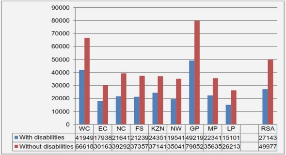
Fishery contributes to 25% of total of food agriculture. Within the archipelago, fisheries play an important role in employment and national food security, since fishery products are generally consumed by poor households and other social communities. Based on data from MMAF, marine capture fisheries production in the 2005-2014 period ranges from 4,408,499 tonnes in 2005 to 6,037,654 tonnes in 2014. The catch production in 2014 was :
• 489,920 tonnes in Malacca Strait and Andaman Sea (8.11%),
• 602,148 tonnes in Indian Ocean of Western Sumatera and Sunda Strait (9.97%),
• 459,749 tonnes in Indian Ocean of Southern Java, Southern Nusa Tenggara, Sawu Sea, and Western Timor Sea (7.61%),
• 665.754 tonnes in Karimata Strait, Natuna Sea and South China sea (11.03%),
• 1,081,178 tonnes in Java Sea (17.91%),
• 750,377 tonnes in Makassar Strait, Bone Bay, Flores Sea and Bali Sea (12.43%),
• 604.515 tonnes in Tolo Bay and Banda Sea (10.01%),
• 482.035 tonnes in Tomini Bay, Maluku Sea, Halmahera Sea, Seram Sea and Berau Bay (7.98%),
• 327.364 tonnes in Sulawesi Sea and Northern of Halmahera Island (5.42%),
• 161.496 tonnes in Cendrawasih Bay and Pacific Ocean (2.67%).
Marine and fisheries biodiversity
Indonesia is located on the center of region with world’s highest marine biodiversity known as the “Coral Triangle” [11]. With this opportunity, the MMAF faces a challenging task. It has to develop the policy that ensuring marine resources are used in a sustainable manner. Meanwhile, the values of the marine and fishery sectors should increase with the main objective to improve the life quality of all Indonesian people.
Based on the marine and fisheries biodiversities, Indonesia divided into twelve ecoregions, namely ; Papua, Banda Sea, Lesser Sundas, Sulawesi Sea, Halmahera, Palawan/North Borneo, Western Sumatra, Tomini Bay, Java Sea, Arafura Sea, Southern Java, and Malacca Strait [12]. The main characteristics of these ecoregions are described below :
1. Papua was ranked as the first ecoregion for marine & biodiversity conservation. Papua has the top coral reef biodiversity, in addition to its particular animals such as endemic fishes, whales, turtles or dugongs. Papua holds many unique genetic species compared to other regions in Indonesia.
2. Banda Sea is the 2nd ranked area for marine & biodiversity conservation. It has high diversities for coral reef species as well. In addition, the location of Banda Sea plays a significant role on the life cycles of sea turtle and blue whales. The latter are still categorized as highly endangered cetaceans.
3. Lesser Sunda plays an important role on migration for large marine mammals like cetaceans. It has an important commercial role on big pelagic fishes. Upwelling in this region provides nutrition to the big pelagic fish.
Table of contents :
Acknowledgments
Acronyms
Abstract
Résumé
Résumé étendu
1 Introduction
1.1 Context of the thesis
1.2 A brief review of INDESO Project
1.3 Thesis motivation and outline
2 Oil Spill Monitoring in Indonesia
2.1 Description of Indonesian waters
2.1.1 General aspects of ocean circulation in Indonesia
2.1.2 Main issue of Indonesia Marine and Fisheries
2.2 Oil spill monitoring as conceived by the INDESO system
2.2.1 Operational
2.2.2 INDESO sites for the oil spill monitoring
2.2.3 System design
2.3 Detection of oil spill using EO-based imagery
2.3.1 Spaceborne/airborne remote sensing
2.3.2 Detection of oil spill based on SAR imagery
2.4 Oil spill transport model
2.4.1 Introduction
2.4.2 Lagrangian 2D Trajectory Model
2.4.3 Mobidrift
2.4.4 Application of Mobidrift in Indonesia’s Oil Spill Trajectory
2.5 Conclusion
3 Oil spill parameter retrieval
3.1 Introduction
3.2 Proposed approach
3.3 Montara SAR based oil detection
3.4 Similarity between SAR oil spill detection and model
3.5 Estimation of oil leakage parameters assimilation of SAR images
3.6 Application to Montara case study
3.7 Conclusion
4 Oil spill risk assessment in Indonesian Fisheries Management Area
4.1 Introduction
4.2 Data and Study area
4.2.1 Study Area
4.2.2 Data Collection
4.2.3 Marine Protected Area Data
4.2.4 Marine fisheries data
4.2.5 Socio-economic data for fishing activities, tourism services and salt ponds
4.3 Proposed methodology
4.3.1 Oil spill risk indices
4.3.2 Environmental and socio-economical vulnerability indices
4.3.3 Global FMA-level risk index
4.3.4 MPA-level vulnerability analysis
4.4 Results and Discussion
4.5 MPA-level risk assessment
4.6 Conclusion and Discussion
5 Conclusions and Perspectives
5.1 Conclusion
5.2 Perspectives
Bibliography